Índice
What Data Does Google Maps Provide?
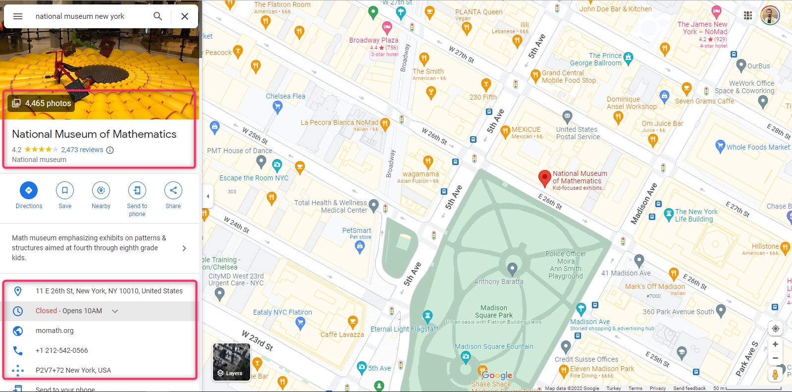
Google Maps holds a lot of information about a location. Photos, reviews, addresses, working hours, website, phone number, plus code are the data shared on the main screen.
Although it is not visible on the main screen, there are many data about the location on Google Maps. Longitude and latitude are two of them. A scraping service must be used to extract all Google Maps data about the location. Outscraper Google Maps Data Scraper is one of these services. Outscraper extracts more than 45 data from a place on Google Maps. The data list is as follows:
- name - nome do local no Google Maps.
- site - site do local.
- type - o tipo do local em que foi encontrado (pode ser qualquer elemento de subtipos).
- subtypes - todos os tipos do lugar.
- category - o tipo principal do lugar (às vezes pode estar em um idioma local).
- phone - número de telefone do lugar.
- full_address - endereço completo do local.
- borough - bairro do local.
- street - rua do local.
- city - cidade do local.
- postal_code - código postal do local.
- state - estado do local.
- us_state - estado do local (será removido em versões futuras).
- country - país do local.
- country_code - código do país do local.
- latitude - latitude do local.
- longitude - longitude do local.
- time_zone - fuso horário do local.
- plus_code - localização plus code ou código de localização aberto (funciona apenas para busca individual, por exemplo, consultar: "Hotel Colombo Berat", "0x3e49a63f6b05fe3b:0xc73d6b1f31b2ccc8").
- rating - classificação do local.
- reviews - número de avaliações
- reviews_link - link para as avaliações do local.
- reviews_per_score - Objeto JSON com avaliações por pontuação.
- photos_count - número de fotos do local.
- photo - link da imagem do local.
- street_view - link de imagem do street view da rua do local.
- working_hours - Objeto JSON com horário de trabalho do local.
- working_hours_old_format - horário de trabalho do local.
- popular_times - horário popular do lugar (funciona apenas para busca individual, por exemplo, consultar: "Hotel Colombo Berat", "0x3e49a63f6b05fe3b:0xc73d6b1f31b2ccc8")
- business_status - situação atual da empresa.
- about - informações extras sobre o local (por exemplo, se identifica como sendo de propriedade de mulheres, receptivo ao público LGBTQ+).
- description - descrição do local.
- range - faixa de preço do local.
- posts - Objeto JSON com as postagens do local (funciona somente para alguns lugares).
- verified - indica se o local foi reclamado.
- owner_id - identificador único do proprietário do local.
- owner_title - título da página de perfil do proprietário.
- owner_link - link para o perfil do proprietário no Google Maps.
- reservation_links - link para fazer a reserva.
- booking_appointment_link - link para marcar uma consulta.
- menu_link - link para o menu.
- order_links - link para fazer um pedido.
- location_link - link para o local no Google Maps.
- place_id - identificador único do local (o Google pode atualizá-lo algumas vezes por ano).
- google_id - identificador único do local, também conhecido como Feature ID (o Google pode atualizá-lo algumas vezes por ano).
- cid - identificação multiplataforma de uma listagem no ecossistema Google.
- reviews_id - identificador único das avaliações dos locais.
Using Outscraper and extracting data is very easy. It is much faster than collecting data manually. It saves time. Let’s look at ways to manually and automatically collect longitude and latitude data from Google Maps.
Collecting Longitude and Latitude Data on Google Maps Manually
Google Maps does not directly show the location’s longitude and latitude information on the home screen. But it can be seen in the right-click menu.
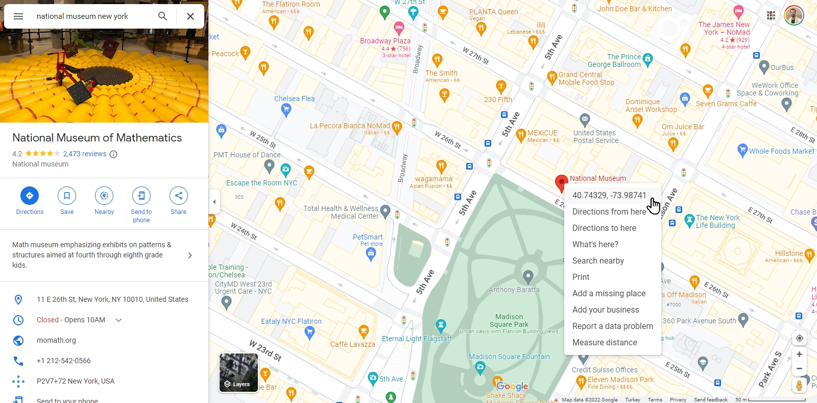
Clicking on the “Longitude and Latitude” line will copy this data to the clipboard. The data “40.7432294426243494, -73.98741247232803” is expressed in a text like this.
So what should you do if you want to find the coordinates of multiple places, for example, all museums in New York? Or from the Google Maps URL list of your locations?
For each location, “hover over the location pin, right-click, copy and paste” steps take a lot of time. Outscraper offers a solution to this issue with its Google Maps scraping service. Coletor de dados do Google Maps do Outscraper service can extract the longitude and latitude data from both categories and URLs in bulk.
How to Extract Longitude and Latitude From Google Maps in Bulk?
There are two ways to extract longitude and latitude with Outscraper’s Google Maps Data Scraper service cumulatively. The first is to create a scraping task by specifying a location and category. The second is to create a task using location URLs.
When creating a scraping task, selecting the location and category is enough. If you need to create more complex tasks, it is recommended that you look at this article: “Como começar com o Google Maps Scraping.”
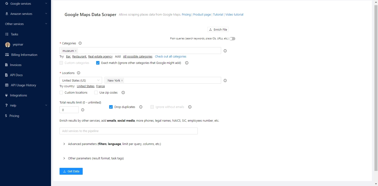
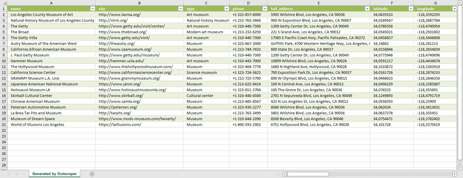
The service will find all the museums in New York and list the coordinates of these museums one by one. It will extract both coordinates and all other data.
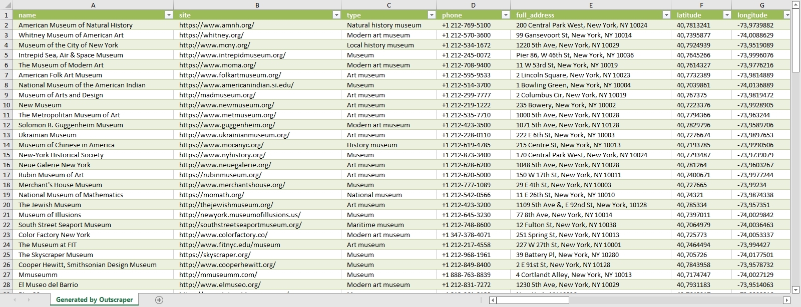
The data of all museums are sorted and listed in the result file. Each place and its data are listed one below the other. The result file can be in CSV/XLSX/JSON/Parquet format. And it can be opened with a spreadsheet viewer like Google Sheets.

“Plain queries” mode must be activated to extract coordinates with Google Maps links. In this mode, a category and location do not have to be selected. It is sufficient to just copy and paste the Google Maps links of the places.
Results will be listed in the same way. It is possible to extract coordinates collectively in both ways. Whichever way is suitable for the intended use is preferred. You can try these two ways by signing up for Outscraper now.
Try for Free Now
It is free to try Coletor de dados do Google Maps do Outscraper service with the free tier. Outscraper bills with the pay-as-you-go model. You only pay for what you use. There is no fixed monthly fee. Test first and then use more for your project.
https://outscraper.com/google-maps-scraper/
Perguntas frequentes
Perguntas e respostas mais frequentes
The only way to search and list all restaurants without skipping any of them is to use zip codes. For this, we recommend that you take a look at the “Scraping All Places From Google Maps” tutorial.
There are more than 650,000 restaurants in the US. The list and dataset of all these restaurants can be obtained with the Outscraper Google Maps Data Scraper service.
The best way to find restaurant data is with Google Maps. Restaurants in all states and cities can be easily found on Google Maps. The data of these restaurants can be extracted with the Outscraper Google Maps Data Scraper service.
There are more than 5,000 categories in Google Maps. Dozens of different categories determine the types of restaurants. Results can be filtered by choosing from these categorias.


Comentário de 0