Inhoudsopgave
What Data Does Google Maps Provide?
Google Maps holds a lot of information about a location. Photos, reviews, addresses, working hours, website, phone number, plus code are the data shared on the main screen.
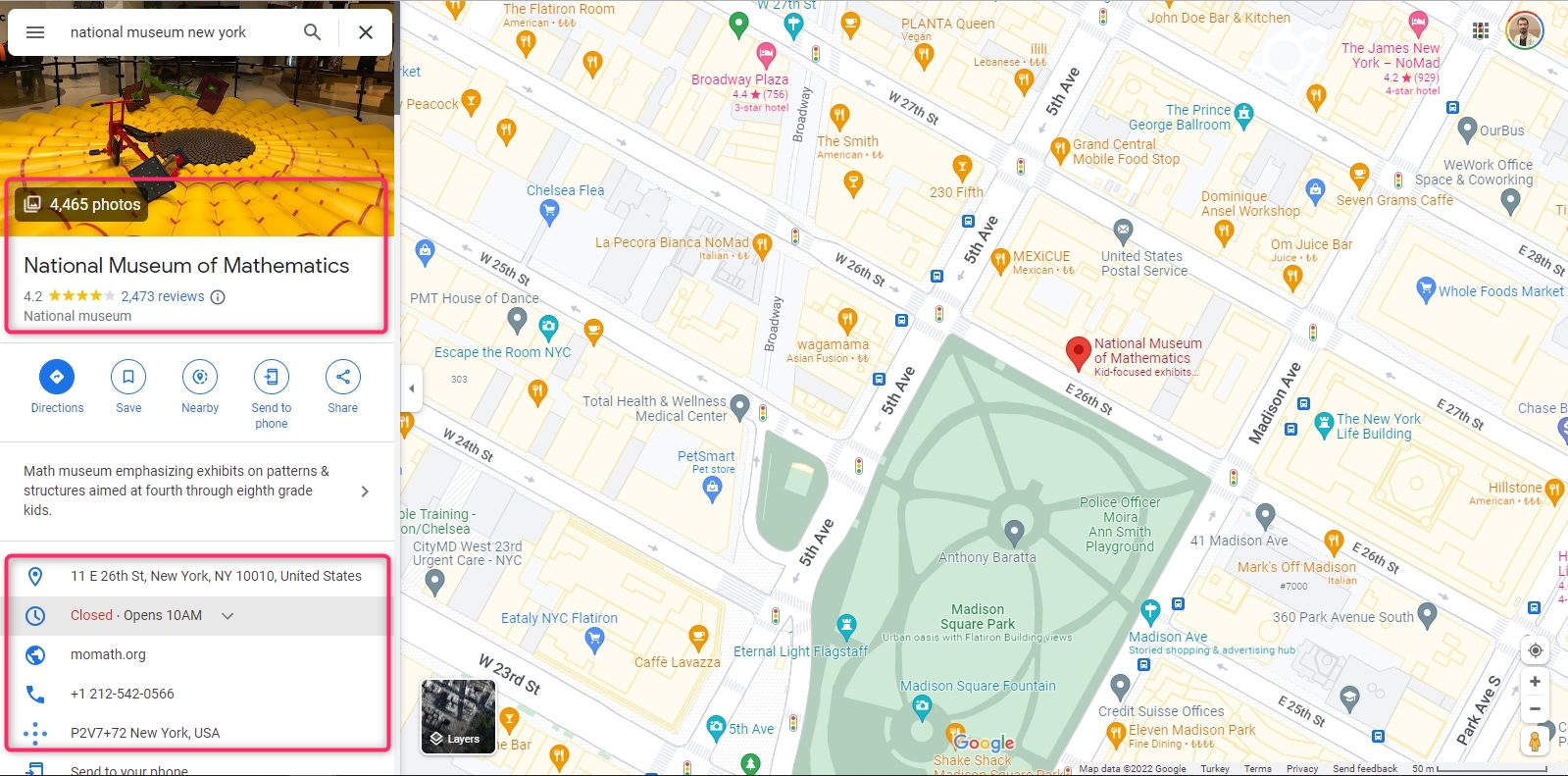
Although it is not visible on the main screen, there are many data about the location on Google Maps. Longitude and latitude are two of them. A scraping service must be used to extract all Google Maps data about the location. Outscraper Google Maps Data Scraper is one of these services. Outscraper extracts more than 45 data from a place on Google Maps. The data list is as follows:
- name - name of the place on Google Maps.
- site - website van de plaats.
- type - the type of the place under which it was found (can be any element from subtypes).
- subtypes - alle soorten van de plaats.
- categorie - het hoofdtype van de plaats (soms in een plaatselijke taal).
- telefoon - plaats telefoonnummer.
- volledig_adres - volledig adres van de plaatslocatie.
- gemeente - gemeente van de plaats locatie.
- straat - straat van de plaatslocatie.
- stad - stad van de plaats locatie.
- postcode - postcode van de plaatslocatie.
- staat - staat van de plaatslocatie.
- us_state - staat van de plaatslocatie (wordt in toekomstige versies verwijderd).
- land - land van de plaatslocatie.
- land_code - landcode van de plaatslocatie.
- latitude - breedtegraad van de plaatslocatie.
- lengtegraad - lengtegraad van de plaatslocatie.
- tijdzone - tijdzone van de plaatslocatie.
- plus_code - locatie plus code of open locatie code (werkt alleen voor individueel zoeken, bijv. query: "Hotel Colombo Berat", "0x3e49a63f6b05fe3b:0xc73d6b1f31b2ccc8").
- beoordeling - beoordeling van de plaats.
- beoordelingen - aantal beoordelingen
- recensies_link - link naar de beoordelingen van de plaats.
- beoordelingen per score - JSON object met beoordelingen per score.
- foto's_telling - aantal foto's van de plaats.
- foto - beeldlink van de plaats.
- straatbeeld - beeldlink van de plaats straatbeeld.
- werkuren - JSON object met werktijden van de plaats.
- werkuren_oud_formaat - werktijden van de plaats.
- populaire tijden - populaire tijd van de plaats (werkt alleen voor individuele zoekopdracht, bijv. query: "Hotel Colombo Berat", "0x3e49a63f6b05fe3b:0xc73d6b1f31b2ccc8").
- business_status - huidige status van het bedrijf.
- over - extra informatie over de plaats (bijv. Identificeert als vrouwvriendelijk, LGBTQ+ vriendelijk).
- beschrijving - plaatsbeschrijving.
- reeks - prijsklasse van de plaats.
- berichten - JSON object met berichten van de plaats (werkt alleen voor sommige plaatsen).
- geverifieerd - geeft aan of de plaats is opgeëist.
- eigenaar_id - unieke identificatiecode van de eigenaar van de plaats.
- eigenaar_titel - titel van de profielpagina van de eigenaar.
- eigenaar_link - link naar eigenaarsprofiel op Google Maps.
- reservation_links - link om te reserveren.
- boeking_afspraak_link - link om een afspraak te maken.
- menu_link - link naar menu.
- order_links - link om een bestelling te plaatsen.
- locatie_link - link naar de plaats op Google Maps.
- plaatsnaam - unieke identificatiecode van de plaats (Google kan deze een paar keer per jaar bijwerken).
- google_id - unieke identificatiecode van de plaats, ook bekend als Feature ID (Google kan deze een paar keer per jaar bijwerken).
- cid - multi-platform ID van een vermelding in Google ecosysteem.
- reviews_id - unieke identificatiecode van de beoordelingen van de plaatsen.
Using Outscraper and extracting data is very easy. It is much faster than collecting data manually. It saves time. Let’s look at ways to manually and automatically collect longitude and latitude data from Google Maps.
Collecting Longitude and Latitude Data on Google Maps Manually
Google Maps does not directly show the location’s longitude and latitude information on the home screen. But it can be seen in the right-click menu.
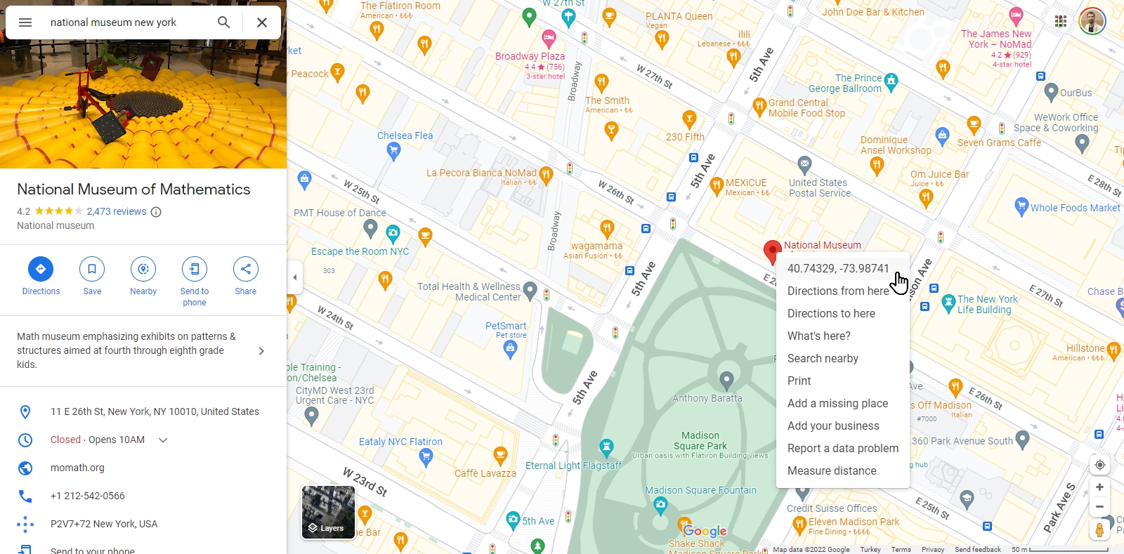
Clicking on the “Longitude and Latitude” line will copy this data to the clipboard. The data “40.7432294426243494, -73.98741247232803” is expressed in a text like this.
So what should you do if you want to find the coordinates of multiple places, for example, all museums in New York? Or from the Google Maps URL list of your locations?
For each location, “hover over the location pin, right-click, copy and paste” steps take a lot of time. Outscraper offers a solution to this issue with its Google Maps scraping service. Outscraper Google Maps gegevensschraper service can extract the longitude and latitude data from both categories and URLs in bulk.
How to Extract Longitude and Latitude From Google Maps in Bulk?
There are two ways to extract longitude and latitude with Outscraper’s Google Maps Data Scraper service cumulatively. The first is to create a scraping task by specifying a location and category. The second is to create a task using location URLs.
When creating a scraping task, selecting the location and category is enough. If you need to create more complex tasks, it is recommended that you look at this article: “Aan de slag met Google Maps Scraping.”
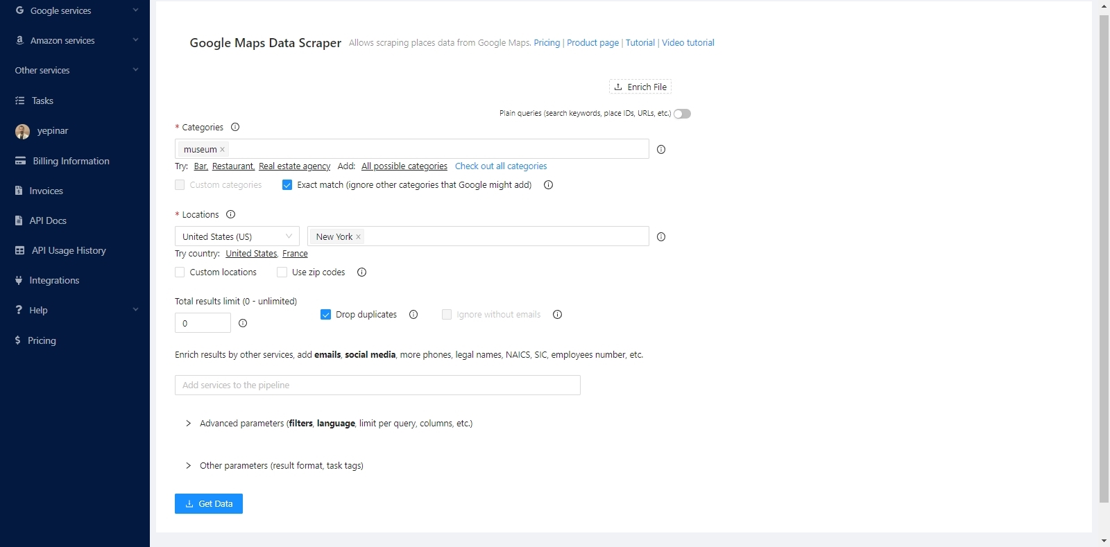
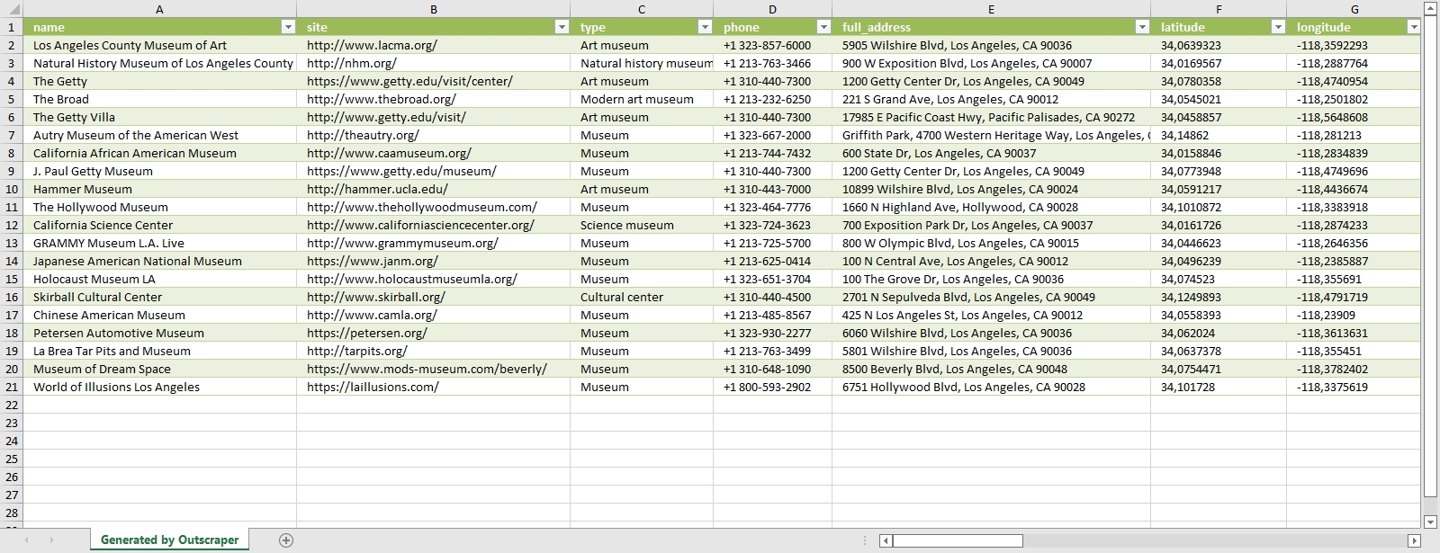
The service will find all the museums in New York and list the coordinates of these museums one by one. It will extract both coordinates and all other data.
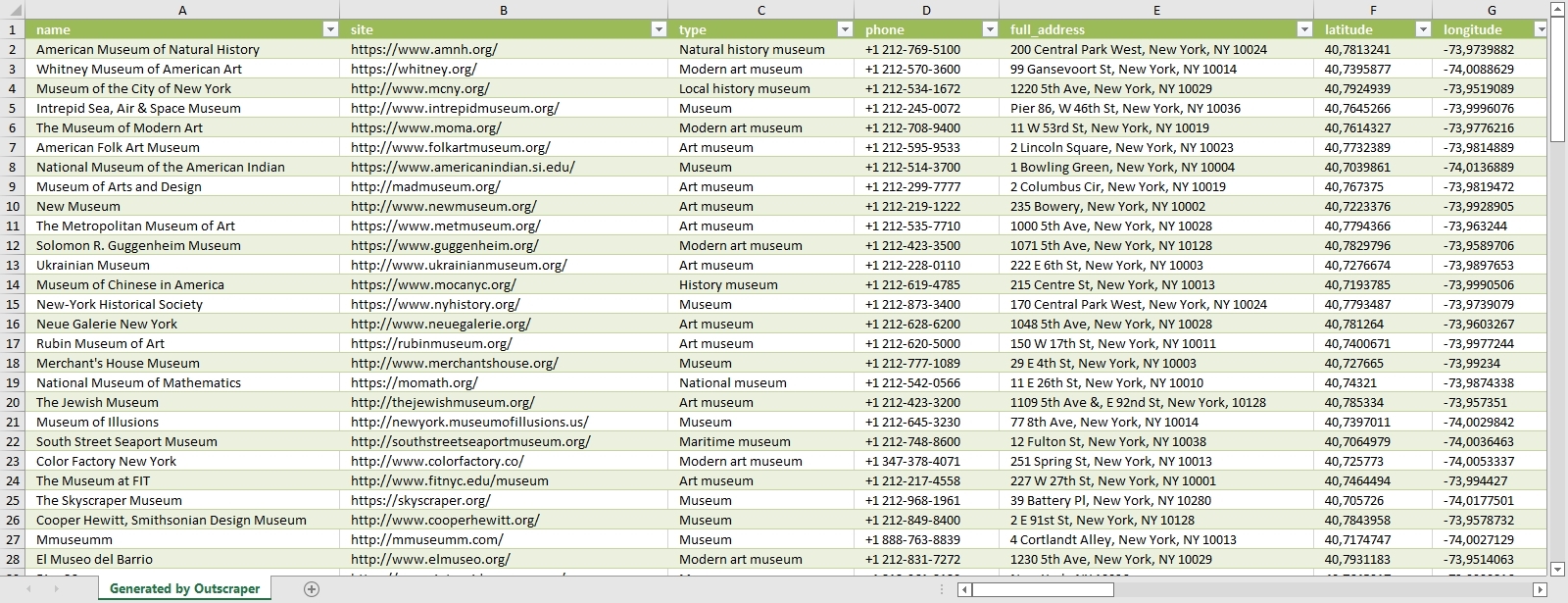
The data of all museums are sorted and listed in the result file. Each place and its data are listed one below the other. The result file can be in CSV/XLSX/JSON/Parquet format. And it can be opened with a spreadsheet viewer like Google Sheets.

“Plain queries” mode must be activated to extract coordinates with Google Maps links. In this mode, a category and location do not have to be selected. It is sufficient to just copy and paste the Google Maps links of the places.
Results will be listed in the same way. It is possible to extract coordinates collectively in both ways. Whichever way is suitable for the intended use is preferred. You can try these two ways by signing up for Outscraper now.
Try for Free Now
It is free to try Outscraper Google Maps gegevensschraper service with the free tier. Outscraper bills with the pay-as-you-go model. You only pay for what you use. There is no fixed monthly fee. Test first and then use more for your project.
FAQ
Meest voorkomende vragen en antwoorden
The only way to search and list all restaurants without skipping any of them is to use zip codes. For this, we recommend that you take a look at the “Scraping All Places From Google Maps” tutorial.
There are more than 650,000 restaurants in the US. The list and dataset of all these restaurants can be obtained with the Outscraper Google Maps Data Scraper service.
The best way to find restaurant data is with Google Maps. Restaurants in all states and cities can be easily found on Google Maps. The data of these restaurants can be extracted with the Outscraper Google Maps Data Scraper service.
There are more than 5,000 categories in Google Maps. Dozens of different categories determine the types of restaurants. Results can be filtered by choosing from these categorieën.


0 Opmerkingen