Table of Contents
Introduction
Selecting the right location is crucial for any retail business. A well-chosen location can drive foot traffic, increase brand visibility, and ultimately boost sales. Around 98% of retail CEOs recognize location intelligence as vital to business success; thus, it helps to give businesses a competitive advantage.
Traditionally, retailers have relied on demographic data, market research, and gut feeling to make site selection decisions. That leads to more challenging tasks in data gathering and analysis, outdated information, and unexpected expenses of time and effort. However, location intelligence and readily available data sources, such as Google Maps, have improved this process.
The integration of Google Maps enriches datasets, including real-time traffic, demographic insights, store location, etc., enabling a data-driven approach to site selection that reduces risk and improves operational efficiency. This article helps in the strategic use of location intelligence, analysis of competitor density, customer behavior, and accessibility, which empowers retailers to align expansion plans with substantiated market realities.
What is a Retail Store?
A retail store is a business establishment that sells goods or services directly to consumers for their personal or household use. It’s the final stop in the supply chain, connecting manufacturers and distributors with the end customer. Retail stores come in various shapes and sizes, from small mom-and-pop shops to large multinational corporations, and they offer a diverse range of products and services to cater to different consumer needs and preferences.
Key Characteristics of a Retail Store:
- Direct Sales to Consumers: The defining characteristic of a retail store is its focus on selling directly to individual consumers rather than to other businesses. This distinguishes it from wholesalers or distributors.
- Physical Location (Traditionally): Traditional retail stores typically have a physical location where customers can browse, examine, and purchase products. This physical presence allows for a tangible shopping experience.
- Inventory Management: Retail stores maintain an inventory of products to meet customer demand. Effective inventory management is crucial for ensuring product availability, minimizing storage costs, and preventing losses due to spoilage or obsolescence.
- Customer Service: Providing excellent customer service is essential for attracting and retaining customers. Retail stores often employ sales associates who can assist customers with product selection, answer questions, and resolve issues.
- Merchandising and Display: Retail stores carefully arrange and display products to attract customers and encourage purchases. Effective merchandising techniques can significantly impact sales.
- Pricing Strategies: Retail stores employ various pricing strategies to maximize profits while remaining competitive. These strategies may include markups, discounts, promotions, and loyalty programs.
- Point of Sale (POS) System: Retail stores use POS systems to process transactions, track sales, and manage inventory. These systems often include features such as barcode scanners, cash registers, and credit card processing capabilities.
Google Maps as a Data Source
Google Maps is a major source of location intelligence that covers geographic coordinates and boundaries, real-time traffic patterns and historical traffic data, business locations, hours, and contact information, user reviews and ratings, street-level imagery (Street View), indoor maps of buildings, public transit routes and schedules. Moreover, Google Maps provides a variety of data points that are relevant to retail site selection, including:
- Points of Interest (POI): POIs represent specific locations that are of interest to people, such as restaurants, cafes, shopping malls, parks, and public transportation hubs. Analyzing the density and types of POIs around a potential location can provide insights into the area’s attractiveness and potential customer base.
- Business Listings: Google Maps contains detailed information about businesses, including their name, address, phone number, website, opening hours, customer reviews, and photos. This data can be used to identify competitors, assess their performance, and understand the local business landscape.
- Demographic Data: While Google Maps does not directly provide demographic data, it can be integrated with other data sources that do. For example, census data, income levels, and population density can be overlaid on Google Maps to understand the demographic characteristics of the surrounding area.
- Traffic Data: Google Maps provides real-time and historical traffic data, which can be used to assess the accessibility of a potential location. Understanding traffic patterns can help retailers determine the best routes for customers to reach their store and identify potential congestion points.
- Geographic Features: Google Maps provides information about geographic features such as roads, buildings, parks, and bodies of water. This data can be used to assess the physical characteristics of a potential location and identify any potential obstacles or advantages.
- Customer Reviews and Ratings: Customer reviews and ratings provide valuable insights into the quality of service and products offered by competitors. Analyzing this data can help retailers identify opportunities to differentiate themselves and provide a better customer experience.
What is Location Intelligence?
Location Intelligence (LI) is the process of deriving meaningful insights from geographic data to solve business problems and improve decision-making. It goes beyond simply mapping data; it involves analyzing spatial relationships, patterns, and trends to understand how location impacts various aspects of an organization’s operations, customers, and market. LI combines Geographic Information Systems (GIS), data analytics, and business intelligence to provide a comprehensive view of the world and how it relates to specific objectives.
Key Components of Location Intelligence
Several key components contribute to the effectiveness of Location Intelligence:
- Geographic Information Systems (GIS): GIS forms the foundation of LI, providing the tools and technologies for capturing, storing, analyzing, and visualizing geographic data. GIS software allows users to create maps, perform spatial analysis, and manage geographic information.
- Spatial Data: This includes any data that has a geographic component, such as addresses, coordinates, postal codes, and boundaries. Spatial data can be sourced from various sources, including government agencies, commercial providers, and internal databases.
- Data Analytics: LI relies on data analytics techniques to extract insights from spatial data. This includes statistical analysis, data mining, machine learning, and predictive modeling.
- Business Intelligence (BI): BI tools are used to visualize and communicate the insights derived from spatial data analysis. BI dashboards and reports provide users with a clear and concise view of key performance indicators (KPIs) and trends.
- Geocoding: The process of converting addresses or place names into geographic coordinates (latitude and longitude). Geocoding enables the integration of non-spatial data with spatial data.
- Reverse Geocoding: The process of converting geographic coordinates (latitude and longitude) into addresses or place names.
- Spatial Analysis: A set of techniques used to analyze spatial data and identify patterns, relationships, and trends. Spatial analysis includes proximity analysis, overlay analysis, network analysis, and spatial statistics.
Location Intelligence with Outscraper
Location intelligence (LI) is the process of deriving meaningful insights from geospatial data. Google Maps, with its vast database of businesses, points of interest, and user reviews, is a rich source of location-based information. Outscraper is a powerful web scraping tool that allows you to extract this data from Google Maps at scale.
By combining these two resources, you can gain a competitive edge by:
- Identifying market opportunities: Discover underserved areas or emerging trends.
- Analyzing competitor locations: Understand your competitors’ strategies and identify potential weaknesses.
- Optimizing your own location strategy: Determine the best locations for your business based on demographic data, foot traffic, and other factors.
- Generating leads: Find potential customers or partners in specific geographic areas.
- Conducting market research: Gather data on customer preferences, pricing, and other market variables.
Using Outscraper for Finding Retail Stores
Outscraper is a popular tool for extracting location intelligence data from Google Maps and other sources. It’s particularly useful for business intelligence, market research, and lead generation.
What Outscraper does:
- Scrapes Google Maps data – business listings, reviews, contact info, ratings, hours, photos, etc.
- Extracts at scale – can pull thousands of locations based on search queries, categories, or geographic areas.
- Exports structured data – delivers results in CSV, Excel, and JSON formats for analysis.
- Email/phone finder – attempts to find contact information for businesses.
- Review monitoring – tracks reviews across locations and competitors
- Data enrichment – add values to the business data extracted, highlighting verified contact information such as emails, phone numbers, business name, etc.
Step-by-Step Guide for Using Outscraper
Outscraper is used for business data and as an enrichment tool. It is widely used as well in building prospect lists for B2B sales, competitive analysis (finding all competitors in a region), market research (understanding business density, types, ratings), local SEO analysis, and lead generation. There are a few easy steps that everyone could follow, without needing technical expertise.
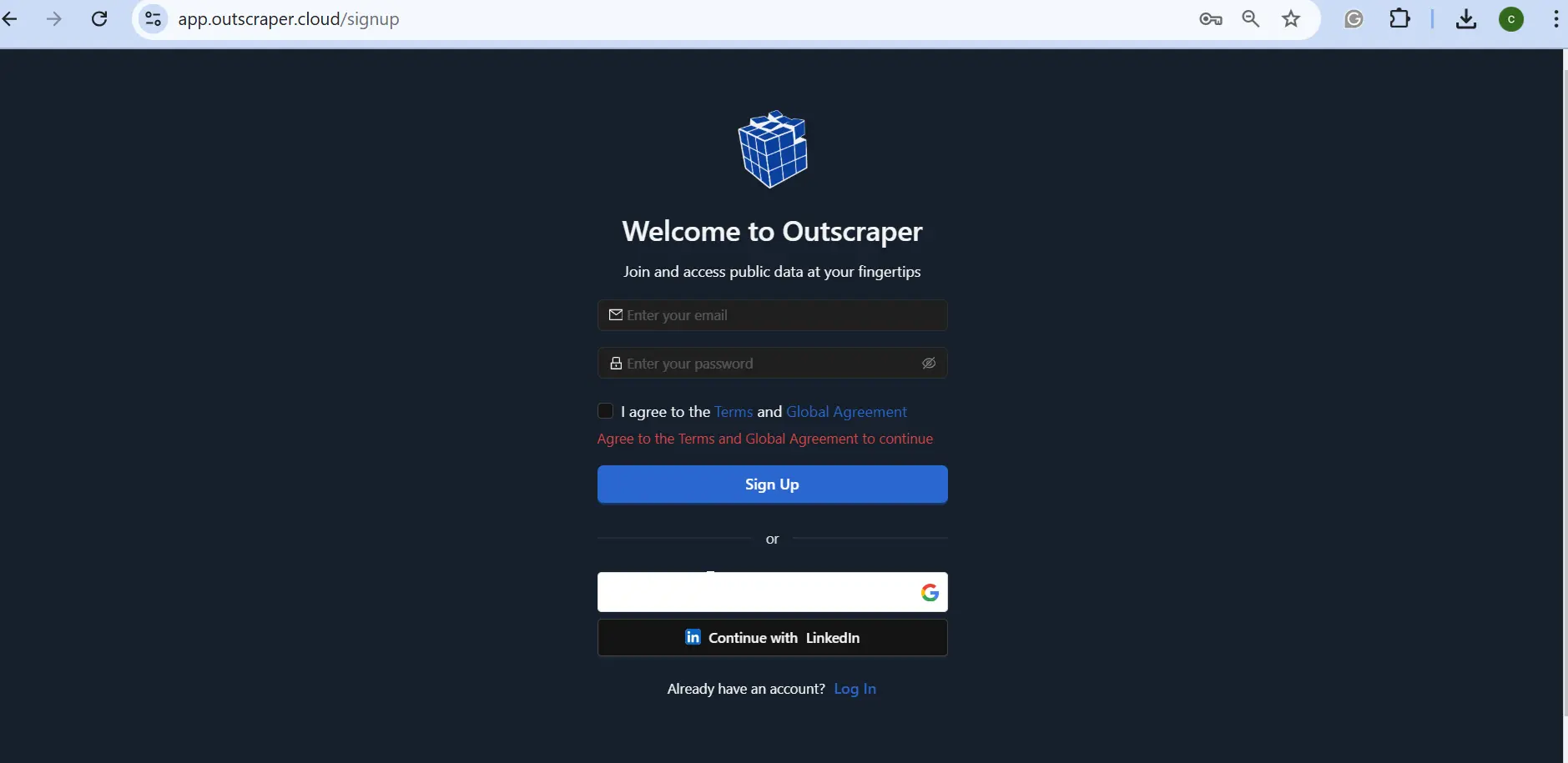
Step 1: Set up an Account
Having an account is necessary; new users can sign up using their email or their Google account. Thus, it can be with the free-tier with 500 requests per month, which would reset after a month of use or upon usage. Lastly, pay-as-you-go pricing for more features and enrichments.
Take note that it will only charge based on the data requested and is not bound to any contracts.
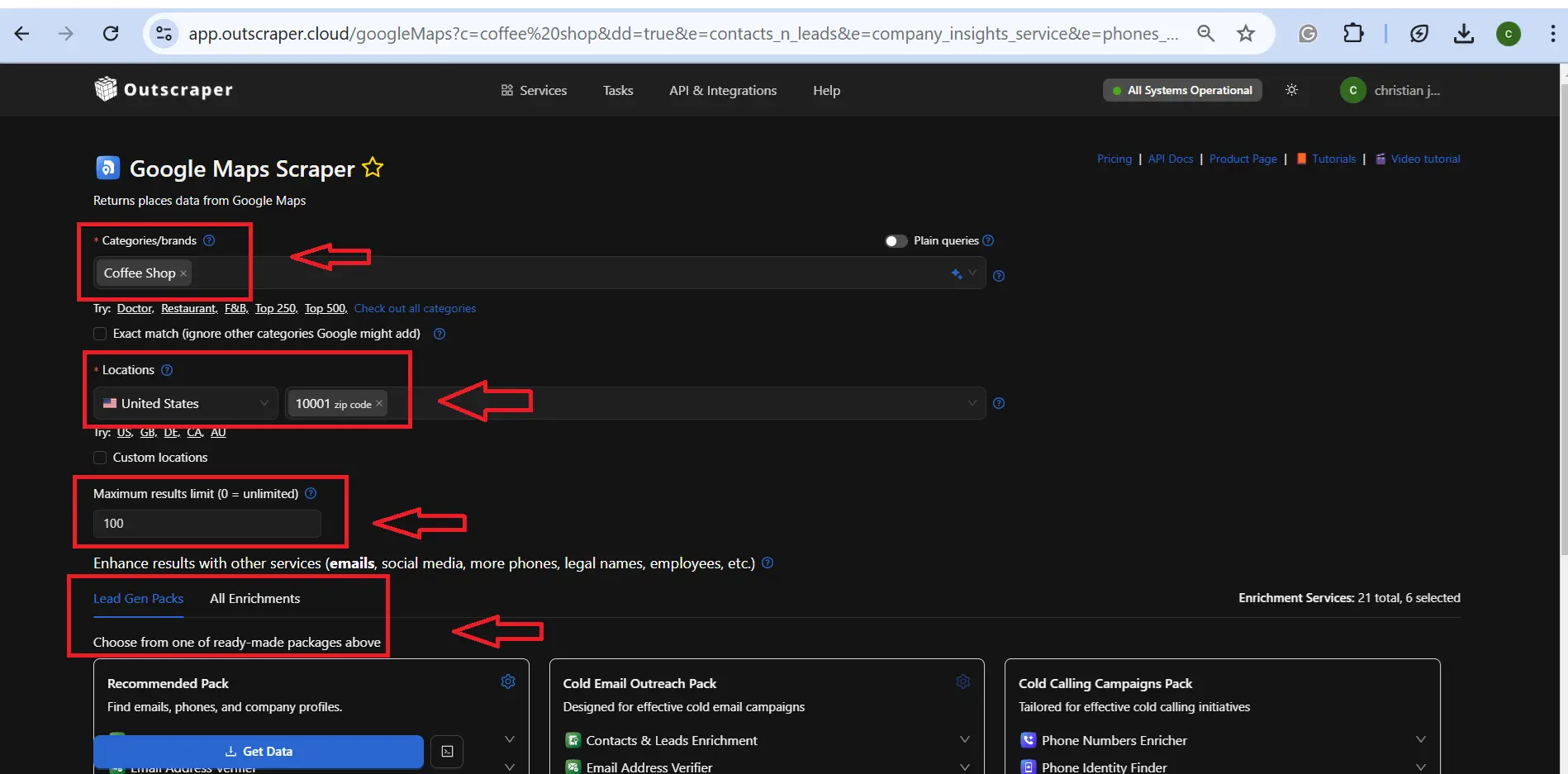
Step 2: Choose Filters
Configuring filters helps to narrow down the desired categories/brands in a specific location. Users may add a maximum limit that would reduce the cost of data extraction. Also, additional enrichments are highly recommended, which can be modified depending on the desired outcome of data extraction.
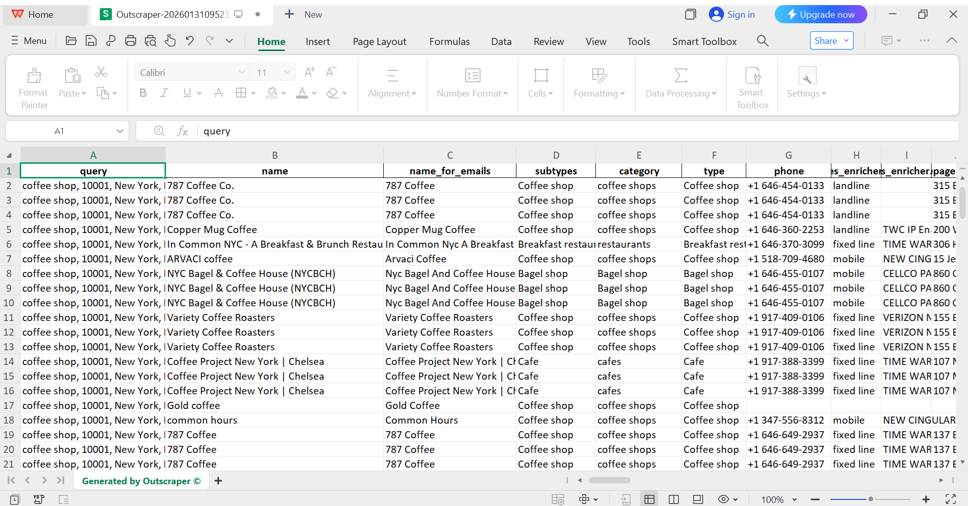
Step 3: Get Data
Export data file into a suitable format, CSV, JSON, Excel, or Parquet. This may take time if users scrape a thousand or more, but when it is done, it can be used for marketing research, data analysis, and lead generation.
Conclusion
Retail site selection depends on accurate location intelligence. It is how Google Maps data provides concrete inputs such as competitor locations, traffic patterns, points of interest, reviews, and accessibility. These inputs support clearer decisions, lower risk, and better alignment between store placement and customer behavior.
Location intelligence turns raw geographic data into operational insight. By combining GIS concepts, spatial analysis, and business intelligence, retailers gain visibility into market density, underserved areas, and expansion feasibility. This approach replaces fragmented research with structured analysis.
Outscraper supports this process by extracting Google Maps data at scale and delivering structured datasets ready for analysis. Retailers use this data to evaluate locations, compare competitors, and plan growth based on evidence rather than assumptions. Using location intelligence with reliable data sources leads to stronger site selection decisions and more efficient retail expansion.
FAQ
Most frequent questions and answers
Location intelligence refers to the process of analyzing geospatial data, such as maps, demographics, traffic patterns, and points of interest, to derive actionable business insights.
A retail store is a business establishment where goods or services are sold directly to individual consumers for personal use. Toggle Content
Verified contact information refers to contact details like email addresses, phone numbers, or physical addresses that have been confirmed as accurate and belonging to the intended person or business through validation processes.
Reputation management involves monitoring, influencing, and maintaining a positive public image for individuals, businesses, or brands, particularly online.
Sentiment analysis determines the emotional tone behind text data, classifying it as positive, negative, or neutral. Businesses apply it to customer feedback, social media, and reviews to gauge opinions and detect trends
Negative reviews signal customer dissatisfaction but can also enhance authenticity and drive sales from discerning buyers. They impact revenue by deterring impulse purchases while offering opportunities for improvement and engagement.
Qualifying opportunities from negative reviews involves scraping feedback for pain points, prioritizing high-intent signals like recent complaints, and personalizing outreach to convert dissatisfied businesses into leads.
Google Maps serves as a public mapping platform providing geospatial data on businesses, landmarks, and properties, including user-generated details like photos, reviews, and contact information, which supports lead generation in digital marketing
An API is a tool that lets you access Google Maps data automatically. With a scraper API, you can quickly gather the information you need.