Table of Contents
What are Geomarketing and Location Intelligence and Why It is Important?
Geomarketing is the use of geographic data to inform marketing strategies and decision-making processes. It involves analyzing data related to the location of customers, businesses, and other points of interest to identify patterns and trends. Location intelligence, on the other hand, involves using location-based data to gain insights and make better-informed decisions.
Together, geomarketing and location intelligence enable businesses and organizations to identify areas of opportunity and optimize their marketing strategies. For example, a retail chain may use geomarketing and location intelligence to identify areas with a high population density and disposable income to open new stores. Similarly, a logistics company may use location intelligence to optimize delivery routes based on traffic patterns and road conditions.
By leveraging the power of geographic data, businesses and organizations can gain a competitive edge, make data-driven decisions, and improve customer experiences. Geomarketing and location intelligence can help companies to identify and understand their target audiences, optimize their marketing strategies, and increase revenue. It is essential in today’s data-driven world, where businesses need to make informed decisions based on data to stay ahead of their competition.
Sample Use Case: Finding Potential New Store Locations
The national retail chain’s data team is responsible for identifying potential new store locations using geomarketing and location intelligence. To do this, they rely on Google Maps data and other data points, such as the proximity to major highways, public transportation, and airports.
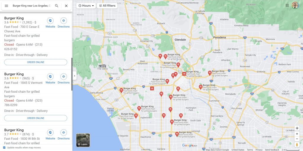
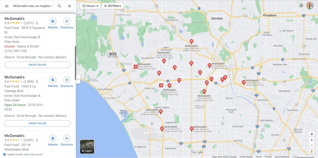
By overlaying the location of their existing stores onto the map, the team can identify areas where there is a gap in coverage and areas where new stores would be most beneficial. They also consider the locations of their competitors’ stores to identify areas with less competition and more significant potential for success. This helps the retail chain make data-driven decisions about new store openings and optimize its marketing strategies. Let’s consider a hamburger shop chain planning to open a new one in Los Angeles. One important detail to consider is the location of Burger King and McDonald’s branches and their proximity to each other. Analyzing this information will help determine the best location for the new shop to compete effectively. Let’s check Google Maps for more insights.
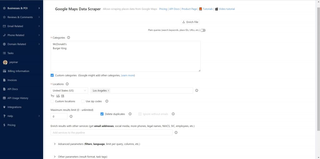
As you can see, only these two companies have dozens of different branches. Here, spacing and gap positioning must be done for a geo-analysis. For this, a dataset including latitude and longitude information is needed. It is very easy to create this dataset with Outscraper Google Maps Scraper. It is enough to create a task to scan Burger King and McDonald’s.
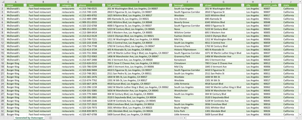
Outscraper will give us all the data we need as a spreadsheet file. You will have quick access to the POI data of all branches. This allows you to focus on the main job and analyze without wasting time with data collecting.
Result file also offers different data for analysis apart from coordinates. Of these, ‘Popular Times‘ is one of the most important details for a restaurant business. Seeing which hours the chain store receives the most traffic will deepen and enrich the analytics data.
In addition to identifying new store locations, location intelligence and geomarketing can also help the retail chain optimize its delivery routes and improve customer experiences. The logistics team can optimize delivery routes by analyzing traffic patterns and road conditions, reducing delivery times, and improving customer satisfaction.
Outscraper has Google Maps Traffic Extractor service to extract traffic data as well as Google Maps Data Scraper service. With this service, delivery routes and delivery times can be optimized by analyzing traffic data in Google Maps.
Outscraper offers facilities for location-based analysis and studies with the services it provides. You can also test Outscraper services for your project.
Try Outscraper Services Now
Outscraper offers a range of services to help you with your geomarketing and location intelligence needs. With Google Maps Scraper and Traffic Extractor services, you can easily collect and analyze data related to your target locations, competitors, and delivery routes. Using Outscraper, you can save time and focus on the main job of analyzing the data to make informed decisions that will help you stay ahead of the competition. Give Outscraper services a try today with free credits and see how they can help you optimize your marketing strategies and improve customer experiences.
Câu hỏi thường gặp
Các câu hỏi và câu trả lời thường gặp nhất
GIS (Geographic Information System) is a framework for gathering, managing, and analyzing spatial data. It allows users to visualize, interpret, and understand geographic data in relation to patterns, trends, and relationships. Location intelligence, on the other hand, is the process of using location-based data to gain insights and make better-informed decisions. While GIS is the technology used to manage spatial data, location intelligence is the application of this data to solve real-world problems and support decision-making processes. Outscraper’s Google Maps Scraper and Traffic Extractor services enable businesses to easily access and analyze location data, providing valuable location intelligence insights.
Location-based intelligence refers to the process of using geographic data, such as the location of customers, businesses, and other points of interest, to derive insights and make informed decisions. It helps businesses and organizations understand the spatial context of their target audiences, optimize marketing strategies, and identify areas of opportunity. Location-based intelligence is a key component of both geomarketing and location intelligence. By using Outscraper’s services, businesses can quickly gather location data and focus on analyzing it to make strategic decisions.
Geomarketing is essential because it allows businesses to make data-driven decisions and optimize their marketing strategies based on geographic data. By analyzing the location of customers, businesses, and other points of interest, organizations can identify patterns and trends that help them target the right audiences, open new stores in strategic locations, and stay ahead of their competition. Geomarketing also enables businesses to improve customer experiences by optimizing delivery routes, tailoring marketing messages, and offering location-specific promotions. Outscraper’s Google Maps Scraper service empowers businesses with the data they need to execute effective geomarketing strategies.
Location intelligence marketing is the practice of using location-based data to create and optimize marketing strategies. It involves analyzing geographic data to better understand target audiences, identify areas of opportunity, and make data-driven decisions. Location intelligence marketing can help businesses optimize their marketing efforts, increase revenue, and stay ahead of the competition. By utilizing Outscraper’s services, businesses can easily access location data and focus on the main job of analyzing the data to make informed marketing decisions, ultimately improving customer experiences and boosting their bottom line.


0 Comments